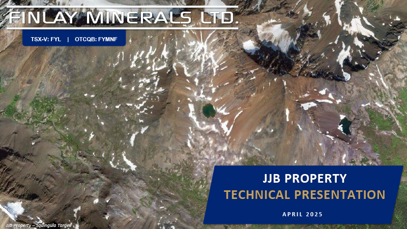
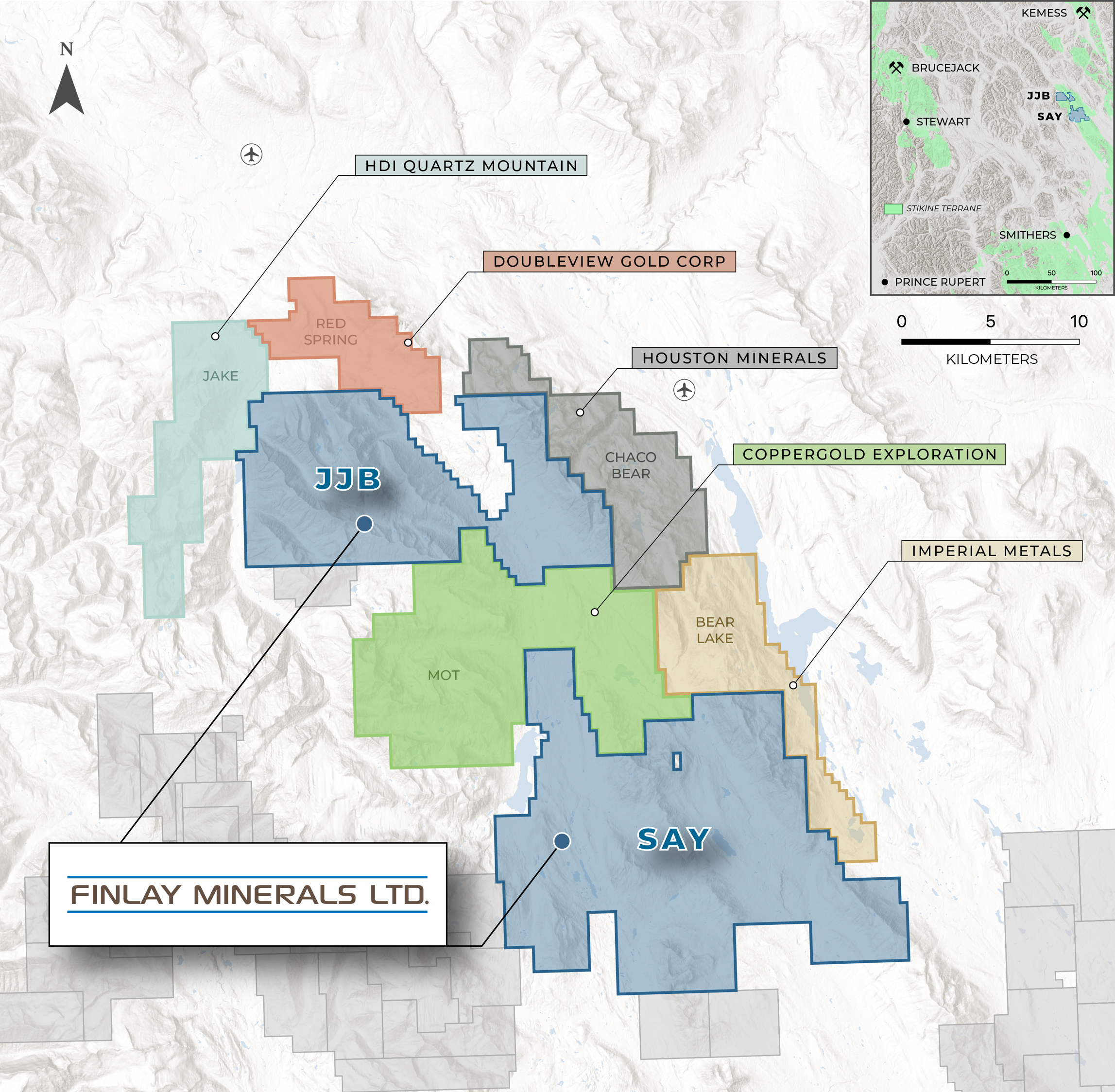
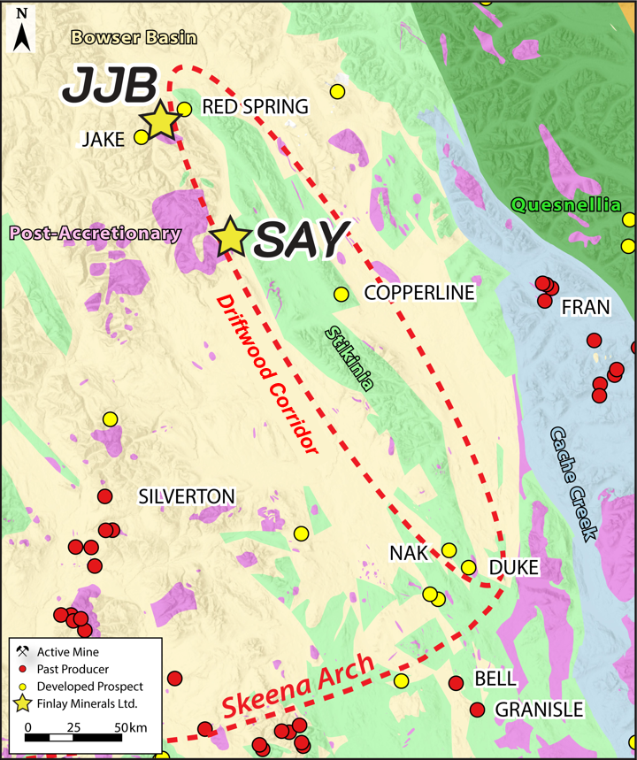
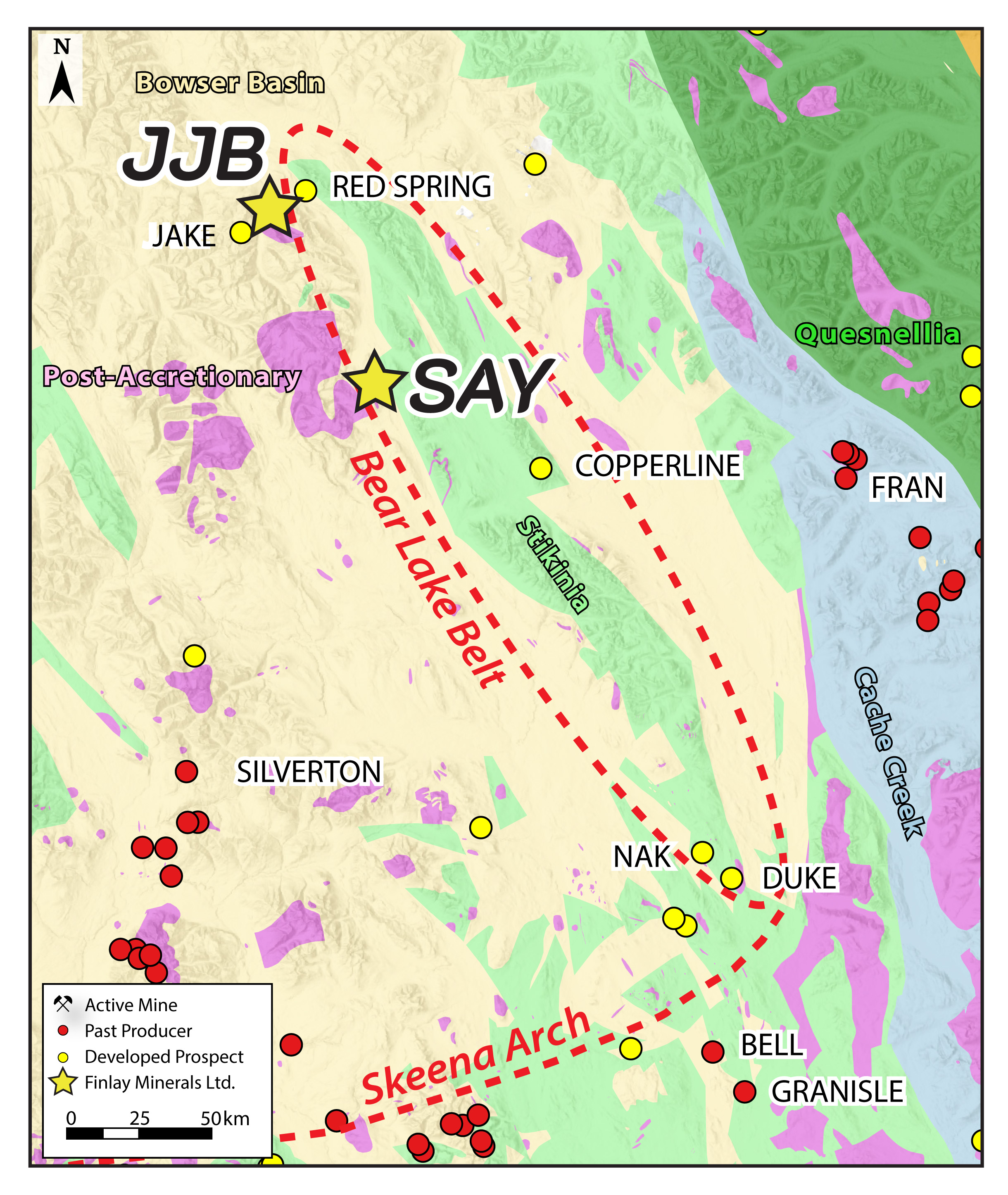
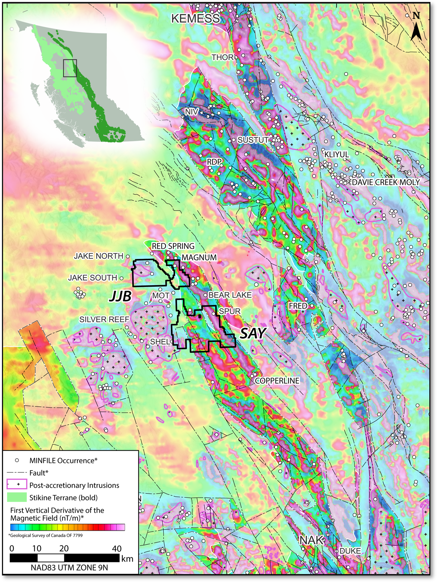
Finlay’s 100%-owned JJB Property covers 15,453 hectares (154 km2) of highly prospective Stikine Terrane, 150 km north of Smithers B.C, and 4 km north of the SAY Property claim boundary. The Stikine Terrane is a tectonic assemblage that hosts the metal endowment in B.C.’s Golden Triangle, the Toodoggone District, and the Skeena Arch. The JJB Property straddles the western margin of the relatively underexplored, 135-km-long, “Driftwood Corridor” of Stikinia, a tectonic position analogous to American Eagle Gold’s Nak Cu-Mo ± Ag ± Au porphyry prospect, 95 km to the south. The Driftwood Corridor hosts several volcanic redbed / sediment-hosted Cu ± Ag showings and prospects including the Copperline and Red Spring prospects. Porphyry prospects throughout the region are associated with post-accretionary Cretaceous – Eocene intrusions in both Stikinia (e.g. Imperial Metal’s Cu-Mo Porphyry Bear Lake Project) and overlying Bowser Basin sediments to the west (e.g. HDI Quartz Mountain’s Cu Porphyry Jake Project).
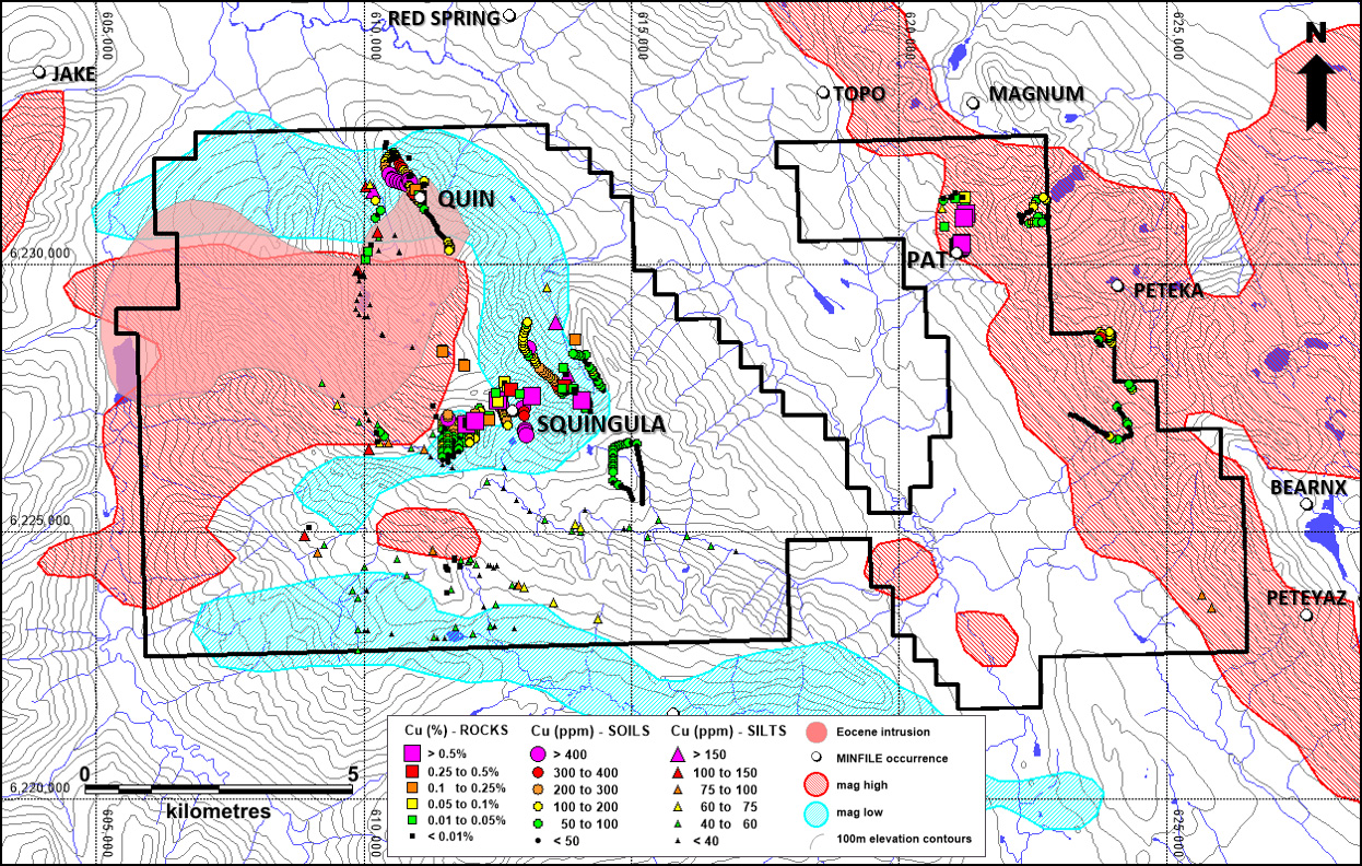
The JJB Property is a prospective, greenfields-stage, copper + gold exploration project with a limited work history. Most importantly, the geological setting at JJB is analogous to mineral deposits within the Driftwood Corridor including Finlay’s 100% owned SAY Property. Historic work programs have identified three Cu +/- Ag-Au-Mo showings on the Property: Squingula, Quin and Pat. The former two showings surround a mapped Eocene intrusion on the west side of the property, which is coincident with a magnetic high. There is a traditional porphyry signature magnetic low present around this magnetic high, that is also coincident with an iron oxide anomaly. The intrusion, magnetic anomaly and iron oxide signature, are all associated with a Cu + Au + Ag geochemical anomaly outlined from limited sampling. Mineralization appears to be controlled by major northwest trending structures and east-west cross structures. Zones of known mineralization occur where these structures overlap. Quaternary till, alluvium and colluvium cover the valley bottoms on the property and JJB staking included these areas where the aforementioned interpreted mineralizing structures are inferred to exist.
An airstrip is located within 10 km of JJB, and nearby logging roads connect with the communities of Smithers and Fort St. James. The property is accessible by helicopter.
The 2026 JJB exploration program is fully-funded to complete mapping, prospecting, soil sampling, and biogeochemical programs at the Quin, Squingula and Pat targets.
The JJB Property is located at the northern end of a 55-km-long, north-northwest-trending, strong magnetic high that hosts several showings and prospects. Projects in the broader region, including the Toodoggone, have demonstrated size potential:
RED SPRING, Sediment Hosted Cu-Ag: 5.0 Mt at 0.5% Cu and 11.9 g/t Ag (1985 non-NI43-101-compliant)
COPPERLINE, Volcanic Red Bed Cu-Ag: 0.9 Mt at 2.0% Cu and 48 g/t Ag (1990 unclassified estimate; non-NI43-101-compliant)
KEMESS SOUTH, Cu-Au +/- Ag-Mo Porphyry, Past Production: 750 M lbs Cu & 3.0 Moz Au from 218 Mt.
SUSTUT COPPER, Volcanic Red Bed Cu: 8.561 Mt with an average of 1.615% Cu* (0.65% Cu cut-off; 2003 non-NI43-101-compliant).
NAK PROPERTY, Cu-Au-Mo Porphyry: Drill hole NAK23-17 with 302.1 m of 0.40% Cu, 0.53 g/t Au and 0.046% Mo from 166.9 m
*See bottom of page for sources.
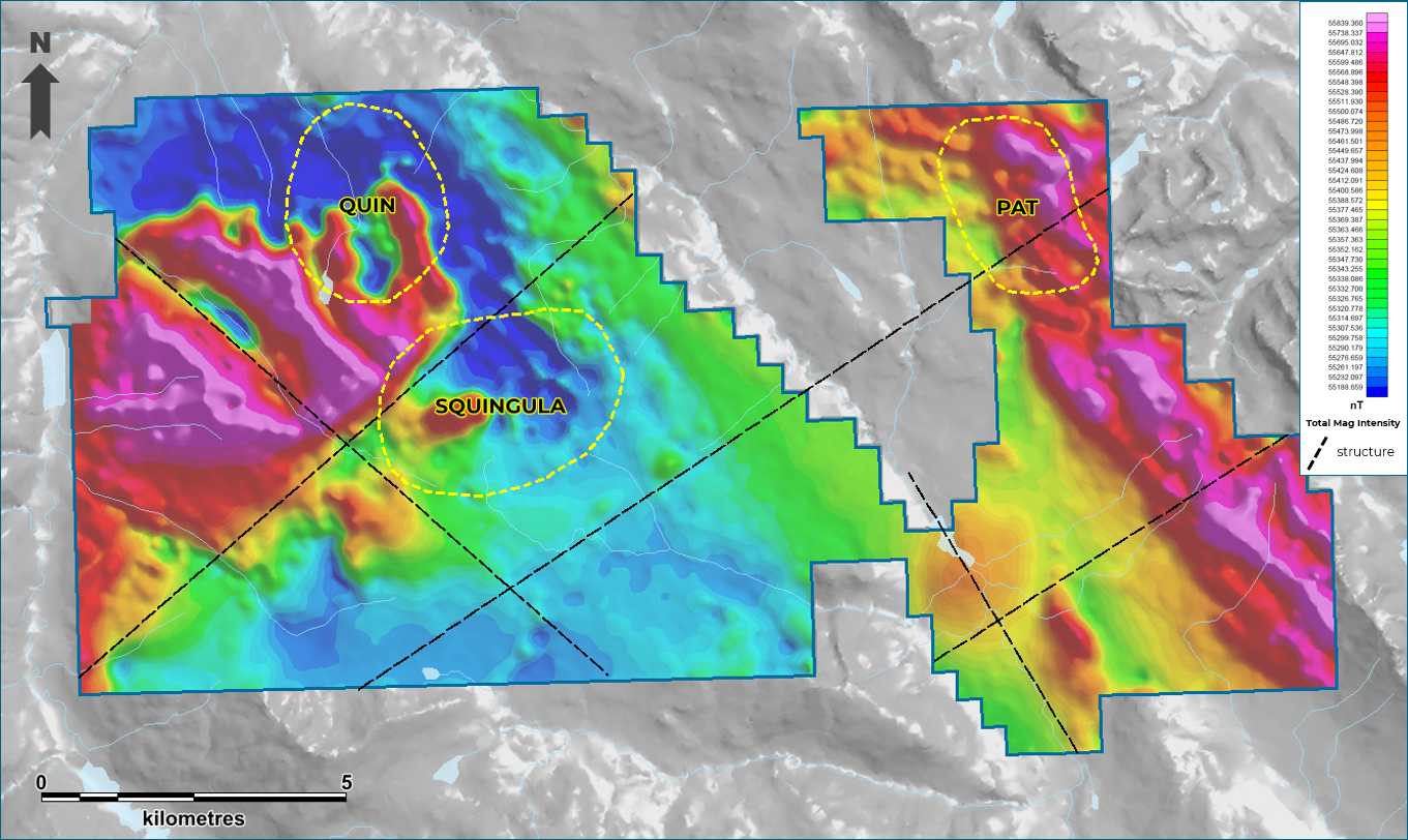
2025 Airborne Magnetics
A 700 line-km airborne magnetics survey was completed during the 2025 field season providing detailed coverage of the JJB property.
Airborne magnetic surveys are a useful exploration tool for porphyry deposits, which generally exhibit characteristic alteration aureoles with associated geophysical responses. The results of the 2025 survey show favourable signatures for porphyry mineralization and cross-cutting linear structures on the JJB property:
Sources:
Kemess South Past Production:
https://www.centerragold.com/operations/kemess-project/kemess-east/
American Eagle Gold NAK23-017 Drill Results:
https://americaneaglegold.ca/news/american-eagle-intersects-302-metres-of-1.09-copper-equivalent-within-606-metres-of-0.74-copper-equivalent/
Sustut Copper 2003 Mineral Resource Estimate (Non-NI43-101-Compliant):
https://minfile.gov.bc.ca/Summary.aspx?minfilno=094D++063
Red Spring Project 1985 Historic Mineral Resource Estimate (Non-NI43-101-Compliant):
https://minfile.gov.bc.ca/Summary.aspx?minfilno=094D%20%20104
Copperline Project 1990 Historic Mineral Resource Estimate (Non-NI43-101-Compliant):
https://minfile.gov.bc.ca/Summary.aspx?minfilno=093M++117